
Highlights: Shorebirds, Waterfowl, Gulls and Terns
Island Park Dam
From Ashton take US 20 north for 26 miles to Pond’s Lodge (located just north of the Buffalo River). Just north of Pond’s Lodge there’s a cross road at the entrance to Buffalo National Forest Campground. Directly across US 20 from the entrance to Buffalo CG is the road to Island Park Dam. There’s a road sign indicating a boat ramp at the turn. After turning off US 20 go .9 miles and you’ll come to a cross road running atop a dike. There’s a public boat ramp straight ahead, the dike road runs north to another more primitive boat ramp or south to Island Park Dam.
In spring the water near the dam attracts rafts of Red-breasted Mergansers and good numbers of Common Loons after ice out. In summers when the water is drawn down enough there is good shorebird habitat and flocks of gulls and terns roost on exposed islands. Fall is good for loons and diving ducks. Rarities recorded at Island Park Dam include all four of Idaho’s loons, all three Scoters, Long-tailed Ducks, Glaucous-winged, Thayer’s, Sabine’s and Little Gulls, Sharp-tailed Sandpiper, and Black-throated Sparrow.
In spring and fall the deeper open water west and north of the dam are good for diving ducks, grebes and loons. The area can be viewed from numerous locations but right next to the spillway at the dam is a great central location from which to scan the open water (in June you can watch Western Grebe’s courtship display from this location). Rafts of Red-breasted Mergansers and concentrations of Common Loons and Western Grebes are typical right after ice out. All of Idaho’s regularly occurring ducks can be found here including Canvasback, Greater Scaup, Ring-necked Duck, Ruddy Duck, and Hooded Merganser. In summer there are islands exposed by the dropping water level that are used for roosting areas by Forster’s and Caspian Terns, Ring-billed, California, and Franklin’s Gulls. In fall Long-tailed Duck, White-winged, and Surf Scoters are rare visitors in fall as are Pacific and Red-throated Loons. Also look for Clark’s, Red-necked and Horned Grebes. Single records exist for Yellow-billed Loon and Black Scoter as well.

After checking the reservoir go back to the road that crosses the dam and proceed across to the large parking lot where a trail accesses the area below the dam. This parking lot is good in June for Hammond’s, Dusky, Cordilleran (rare), and Olive-sided Flycatchers, Stellar’s Jay, Western Tanager, and MacGillivray’s Warbler. The trail begins at the SW corner of the parking lot and parallels the Henry’s Fork all the way to Harriman State Park 8 mile downstream. The upper end of the trail (the first couple miles) has Williamson’s Sapsucker (common, listen for drumming), Three-toed and Black-backed Woodpecker (both rare), Ruffed Grouse, and occasionally Golden-crowned Kinglet and Red Crossbill.
Now drive back across the dam and check the Black Willow trees along the reservoir side of the road. Typical riparian nesting species are common here including Red-naped Sapsucker, Warbling Vireo, Yellow Warbler, Song Sparrow, Red-winged Blackbird, Bullock’s Oriole and Northern Waterthrush. Sora and Pied-billed Grebe can sometimes be heard calling from the cattails in the small bay near the road and Canvasback nests here as well. During migration large flocks of sparrows can be found along the dike. These typically contain White-crowned, Chipping, Brewer’s, and Vesper Sparrows but Sage and Black-throated Sparrows have also been seen here. Northern Shrikes are regular in fall. Northern Waterthrushes breed in the willows along the lakeshore and can usually be found in multiple locations between the dam and first boat ramp.
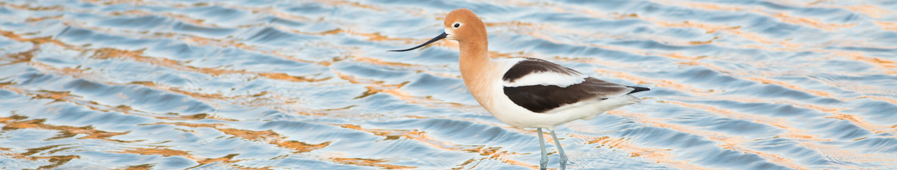
Depending on water level there are a few to many small islands in the area between the boat ramp and the dam. These are used heavily by terns and gulls in summer and fall. A Little Gull spent a few days here in 2005. If there are muddy areas exposed you can find shorebirds in this area from late July through October. Depending on when you visit Killdeer, Greater and Lesser Yellowlegs, Least, Western, Baird’s, Pectoral, Semipalmated, Spotted, Solitary, and Stilt Sandpipers, Long-billed Dowitcher, American Avocet, and Willet can all be found here. Black-bellied and Semipalmated Plovers, and Sharp-tailed Sandpiper have also been seen here. Migrant flocks of sparrows and warblers can be found in thickets along the shoreline during fall. Expected species include Yellow, Yellow-rumped, Orange-crowned and Wilson’s Warblers, Song, Lincoln’s and White-crowned Sparrows. Townsend’s Warbler is also possible in fall.

West End Campground
From Ashton take US 20 north for about 17.5 miles to Green Canyon Rd. There are signs here for Harriman State Park which you enter from Green Canyon Rd. Turn left on Green Canyon Rd. but don’t enter the state park. Continue past the entrance to Harriman Park for nine miles to West End Campground.
ALTERNATE ROUTE: In early spring (through mid May most years) Green Canyon Rd. is not yet free of snow so you need to access the west end locations via Kilgore-Yale Rd. (a.k.a. Fremont County A2). To get there continue north on US 20 for another 10.7 miles and turn left (west) on Kilgore-Yale Rd. Go about 3.9 miles to Old Shotgun Rd. and turn left. This is a dirt road that often has puddles right after snow melt but it’s a good road and you shouldn’t get stuck anywhere. Go approximately 10 miles to Green Canyon Rd. and turn left. Green Canyon Rd. is not marked here but you can see the reservoir to the south as you drive on Old Shotgun Rd. and it’s the only good dirt road to the south in this area. The first bridge you come to is Sheridan Creek.
This area is best in late summer and fall and has a great mix of habitats for passerines as well as water birds. The main lake here is good for ducks, grebes, loons, gulls and terns. The shoreline consists of numerous “fingers” jutting out into the reservoir creating a series of narrow bays. The bays are lined with willows and attract migrant flocks in fall. Rarities found here include Purple Finch and Magnolia Warbler but the area is seldom birded and undoubtedly attracts many more vagrants. The upper end of the bays can be good for shorebirds depending on water level so they’re worth checking any time during summer or fall. During some years the reservoir level is very low so most of the western shoreline is visible here. Adjacent coniferous forests contain typical breeding species and also attract migrants in late summer/fall. Spring can be good for ducks and gulls on the reservoir and you’ll probably rely mostly on a scope. The best strategy is to drive along the shoreline and park frequently to check brush along the shoreline and scope the reservoir and any visible mud (fall).
Warning – Be very careful not to drive too far out into the mud. The ground is often saturated beneath a dry crust so stay well back from anything that looks wet.

You can also launch a boat in this area (at the public boat ramp or right off the bank for canoes or kayaks) and access the entire west end by water. This can be an exciting way to cover the reservoir as birds will let you approach very closely when you’re in a boat, sometimes within 5 feet.
Mouth of Sheridan Creek
Drive past West End Campground about 2.5 miles and the road turns north away from a ridge to the south. In about 2.3 miles you cross a wooden bridge over Sheridan Creek. Park here and walk down the creek about 1.5 miles to the shoreline. Which side of the creek you walk down is a judgment call. The north side is usually best in spring but either can be good in fall. If possible be prepared to cross the creek if necessary (which often is not possible in spring). SEE ALTERNATE ROUTE above.
This is the single best shorebird location, and is the only good location during spring migration, but don’t overlook the flooded Sagebrush when Sheridan Creek is out of its banks (a pair of White-rumped Sandpipers once spent an afternoon in flooded Sage just upstream from the bridge on Green Canyon Rd). When the reservoir is full or nearly so most shorebirds will be right at the mouth of the creek (see note below). When the reservoir level is lower (85-95%) a narrow peninsula 1/4 mile south and the shoreline north to the mouth of Icehouse Creek (about .7 miles) can also be good. Large numbers of puddle ducks and geese use this area in spring, Sandhill Cranes nest here, terns and gulls roost in good numbers, and Peregrine Falcons hunt the area regularly. When the reservoir is very low you can’t get to the shore because of the mud and taking a boat from West End Campground is a much better option.

All the usual shorebird species can be found here annually. Dunlin, Sanderling and Short-billed Dowitcher and regular spring visitors (mid May is prime time) and American Golden Plovers are regular in fall (usually mid Sept on). Rarities recorded here include Whimbrel, Ruddy Turnstone, Red Knot, Hudsonian Godwit, Glossy Ibis, Arctic Tern, Little and Mew Gulls.
Note: When walking down the north side of Sheridan Creek you actually want to stay on the north side of a canal the creek used to run down. The canal has now been dammed and flows have been restored to the historical channel. When you get about half way (or a little more) you’ll come to a dirt mound about 6 feet high that dams off a canal Sheridan Creek used to run down to the lake. Cross the canal here, then look for two more dirt mounds and head towards the furthest one and cross the canal again. Then walk down the canal to the reservoir. During May it is usually necessary to wear waterproof boots (rubber boots not waterproof/Goretex type leather boots), the higher the better.
Cliff Weisse